Located in Ulju-gun, Sinbulsan Mountain is 1,159 meters above sea level and is part of the Yeongnam Alps mountain range near Ulsan, and is part of the main ridge of the Yeongnam Alps. The circular ridge between Yeongchuksan Mountain and Sinbulsan Mountain offers a unique charm distinct from other mountains in Korea. The area around Sinbulsan Mountain is particularly famous for its expansive silver reed plains in autumn.
Trail Overview
The Shinbulsan mountain hike is centered around Ganwoljae and the summit ridge of Ganwolsan. The most representative course starts from the Yeongnam Alps Complex Welcome Center (H2). There's also a long-distance route that traverses the main ridge from Baenae Pass (H1) to Jisan Village (H3). Depending on the conditions, there are several escape points along the way.
The area around the summit of Sinbulsan (P3), in the center of the main ridge, is particularly famous for its silver reed plains in autumn, but the scenery is beautiful year-round. The main course, starting from the Welcome Center, is perfect for a day trip.
The main ridge begins at Baenae Pass (H1) and winds between Yeongchuksan Mountain (P4), offering sweeping views and a steady breeze. You can enjoy the charm of a highland plain rarely seen in other Korean mountains.
Core Ridge Routes
Representative routes that reach Sinbulsan’s summit ridge.
| Course | Estimated Time (h) | Map Distance (km) | Elevation Gain|Loss (m) | Distance Ascent|Descent (km) | Gradient Ascent|Descent (%) | Difficulty |
|---|---|---|---|---|---|---|
Welcome Center – Sinbulsan (loop) | - | - | - - | - - | - - | star_borderstar_borderstar_borderstar_borderstar_border |
Baenaegogae – Welcome Center | - | - | - - | - - | - - | star_borderstar_borderstar_borderstar_borderstar_border |
Jisan Village – Welcome Center | - | - | - - | - - | - - | star_borderstar_borderstar_borderstar_borderstar_border |
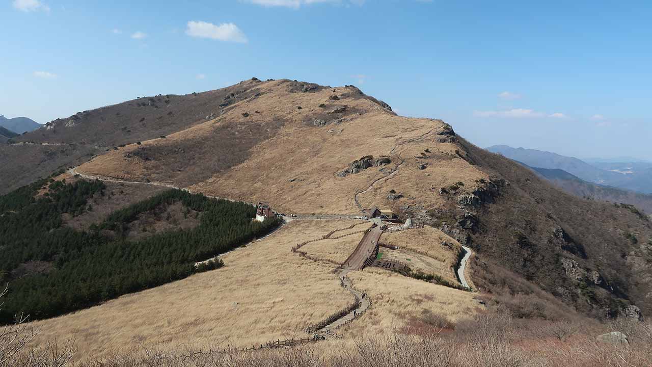
From the Yeongnam Alps Welcome Center (H2), ascend the Kalbawi Ridge(Knife-edge Ridge) Trail to the summit of Sinbulsan (P3). From here, descend to Ganwoljae (K1) and follow the forest road back to the starting point (H2). The trail from Ganwoljae (K1) back to the starting point (H2) is a paved forest road that is approximately 4km long. The rocky ridge trail to the summit of Sinbulsan (P3) offers breathtaking views and a thrilling experience. However, it features many steep cliffs requiring ropes and long, short sections of razor-sharp rock. Therefore, hiking boots are essential. Avoid hiking after rain or in winter, especially if you lack stamina and courage. Furthermore, the rocky paths are dangerous and the trail is unclear, so solo trekking is not recommended. The area around Sinbulsan (P3) and Ganwoljae (K1) is one of the most famous silver reed plains in Korea. Visiting in autumn and witnessing this landscape for the first time will be an unforgettable experience. This course is the most representative course for climbing Mt. Sinbul, and you will be especially impressed on a nice autumn day.
- Restroom: H2, K1
- Parking: H2
This course is a 9.8km course that begins at Baene Pass (H1) and travels along the main ridge of the Alps, passing through Baene Peak (P1), Ganwolsan Mountain (P2), Ganwoljae (K1), and the summit of Sinbulsan Mountain (P3). It then descends along the Kalbawi Ridge(Knife-edge Ridge) to the Welcome Center (H2). Compared to the circular course starting from the Welcome Center (H2), this course is approximately 1km longer and, due to its higher starting altitude, offers a lower overall ascent and greater descent. Furthermore, the descent from the Kalbawi Ridge is more challenging and dangerous than the ascent. If you're feeling exhausted, after rain, or in winter, it's recommended to avoid the Kalbawi Ridge and instead return to Ganwoljae (K1) from the summit of Sinbulsan Mountain (P3) and then descend via the forest road. This course offers the advantage of following the main ridge of the Alps, passing through major peaks, and offering a relatively low elevation gain.
- Restroom: H1, K1, H2
- Parking: H1, H2
Starting from Jisan Village (H3), the trail climbs a steep slope to Yeongchuksan Mountain (P4), then crosses a plateau to reach Sinbuljae (K2) and Sinbulsan Mountain (P3). From Sinbulsan Peak (P3), descend to Ganwoljae (K1), then follow the paved forest road to the Welcome Center (H2). The initial climb to Yeongchuksan (P4) is steep and requires considerable stamina. The trail continues to Ganwoljae (K1), a rare plateau near the tree line in Korea. Unlike most Korean mountain peaks and ridges, this section features rounded or flat ridges and summits, creating wetlands and reed fields, offering a unique experience of the Alps' unique charm.
- Restroom: K1, H2
- Parking: H1, H2
Long distance ridge courses
Longer point‑to‑point links across the ridge. Plan transport and weather buffers.
| Course | Estimated Time (h) | Map Distance (km) | Elevation Gain|Loss (m) | Distance Ascent|Descent (km) | Gradient Ascent|Descent (%) | Difficulty |
|---|---|---|---|---|---|---|
Baenaegogae - Jisan Village | - | - | - - | - - | - - | star_borderstar_borderstar_borderstar_borderstar_border |
Baenaegol – Baenaegogae | - | - | - - | - - | - - | star_borderstar_borderstar_borderstar_borderstar_border |
This course begins at Benae Pass (H1) and follows the main ridge of the Alps to Yeongchuksan Mountain (P4). The section from Benae Pass (H1) to Ganwolsan Mountain (P2) is largely a forested path, like other ridges in Korea. The section leading to Yeongchuksan Mountain (P4) is a rare example of a highland plain, a section rarely seen in Korea, and once explored, it's a section that's hard to forget. This course connects these two distinct sections in one go. As you can see from the elevation chart below the map above, the starting point is high, with greater descent than ascent, making it a relatively easy course to complete. However, the trail from Yeongchuksan Mountain (P4) to Jisan Village (H3) is very steep and can be dangerous for those with low stamina, so caution is advised.
- Restroom: H1, K1, H3
- Parking: H1
This course begins at Benae Valley (H4), ascends to Yeongchuksan Mountain (P4), and then travels along the Alps ridge to Baenae Pass (H1). Except for the fact that the starting point is Benae Valley (H4), it's the reverse of the Benae Pass (H1) - Jisan Village (H3) course, marking the latter half of the Alps Taegeuk Trail. While the distance is slightly longer, the first 1.5km or so is flat, and the climb to Yeongchuksan Mountain (P4) is relatively gentle, making for a less strenuous climb. Note that there are no hiking support facilities near the starting point.
- Restroom: K1, H1
- Parking: H1