Jirisan National Park is Korea's first and largest national park. Spanning the three provinces of Jeollabuk-do, Jeollanam-do, and Gyeongsangnam-do, it is the largest mountain in South Korea and is renowned for its diverse flora and fauna, as well as its many rest areas perfect for overnight stays.
The highest peak is Cheonwangbong, which straddles Hamyang and Sancheong counties in Gyeongsangnam-do. In addition to Cheonwangbong, numerous other peaks, including Banyabong, Nogodan, Jungbong, and Baraebong, form a vast mountain range.
For Korean mountaineering enthusiasts, Seoraksan resembles a general, while Jirisan evokes the soft and warm feeling of a mother's embrace during childhood.
Trail Overview
Jirisan's main ridge is approximately 25km long, and the combined ascents and descents add up to 40km, making it extremely difficult to hike the entire mountain in a day. Furthermore, Baraebong is separated from the main ridge. It's easy to divide the mountain into the eastern region, centered around Cheonwangbong, and the western region, which includes Banyabong, Nogodan, and Baraebong.
Typical trails include the Jungsan-ri and Baekmudong trails, which ascend Cheonwangbong (P1), the highest peak in the eastern region. Both trails lead to the summit, Cheonwangbong. There are also trails that traverse the main ridge, such as the Hwadae Jongju (H1-H4, 40km), and trails that ascend relatively low peaks, such as Baraebong (P4).
Due to the significant elevation, distance, and exposure, the mountain is particularly cold and vulnerable to wind in winter. Advance reservations are required for shelter accommodations for the ridge hike or sunrise hike.
Below are representative areas of Jirisan. Most actual hiking trails pass through one or more of the areas listed below.
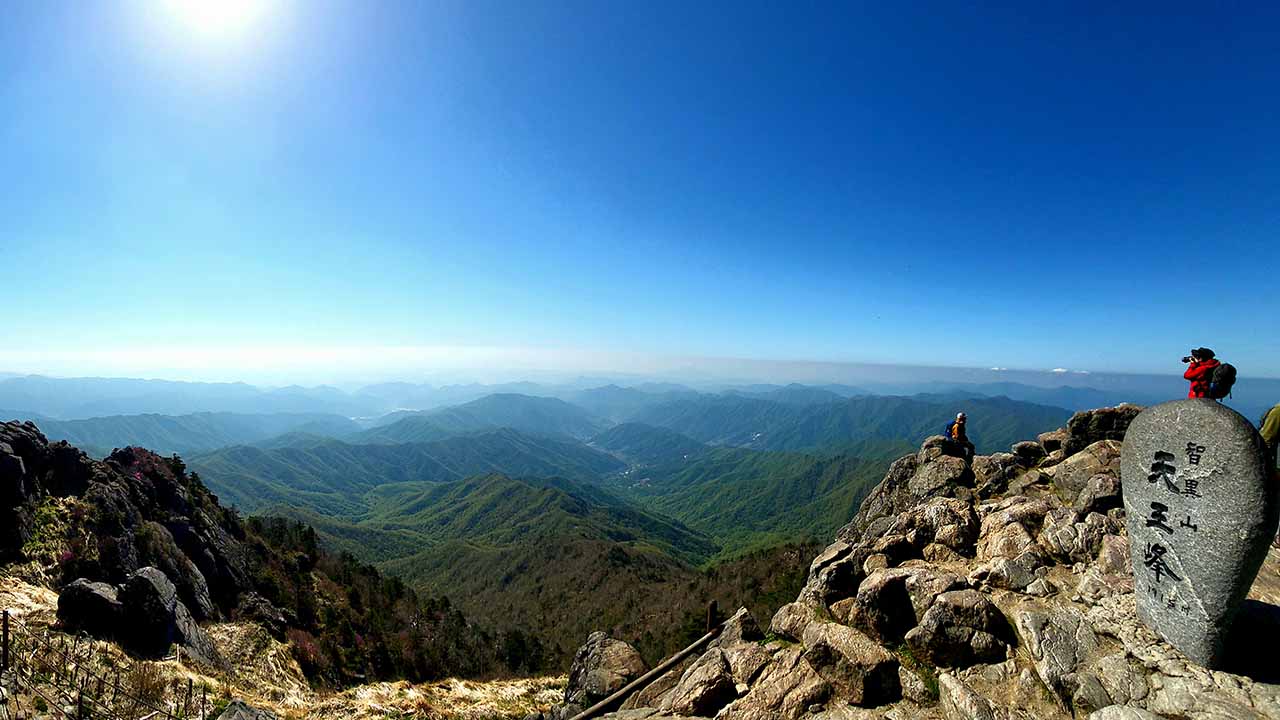
As the highest peak of Jirisan, most climbers ascend or descend from either Jungsan-ri (H2) or Baekmudong (H7).
There are various combinations of courses connected to trailheads such as Seongsamjae (H5), Hwaeomsa (H2()), Baemsagol (H6), and Piagol (H3).
A single course separated from the main ridge of Jirisan Mountain
Eastern Region Courses
The courses introduced here are representative courses that climb Cheonwangbong (P1).
| Course | Estimated Time (h) | Map Distance (km) | Elevation Gain|Loss (m) | Distance Ascent|Descent (km) | Gradient Ascent|Descent (%) | Difficulty |
|---|---|---|---|---|---|---|
Jungsan-ri - Cheonwangbong (round trip) | - | - | - - | - - | - - | star_borderstar_borderstar_borderstar_borderstar_border |
Baekmudong - Cheonwangbong (round trip) | - | - | - - | - - | - - | star_borderstar_borderstar_borderstar_borderstar_border |
Jungsan-ri - Baekmudong | - | - | - - | - - | - - | star_borderstar_borderstar_borderstar_borderstar_border |
Jungsan-ri - Seseok Shelter - Baekmudong | - | - | - - | - - | - - | star_borderstar_borderstar_borderstar_borderstar_border |
This is a typical round-trip route from Jungsan-ri (H2) to Cheonwangbong (P1).
Overall, it's the shortest and steepest route, with few flat sections. The lower section features a forest path and a deck, while the upper section consists of long stone steps and slabs. The trail becomes more rugged and windy as you approach the summit. There's a rotary shelter (S2) about 1km below the summit.
Many hikers choose this route to view the sunrise at Cheonwangbong (P1). It requires an early start and is recommended to check the departure and sunrise times according to the season.
- Restroom: H2, S2
- Restorent: H2
- Parking: H2
The climb from Baekmudong (H7) to Jangteomok Shelter (S3) and Cheonwangbong Peak (P1) is long but moderately gradual.
Compared to the Jungsan-ri route, this hike offers the unique charm of the 1.6km Jirisan ridge and places less strain on the knees during the descent, but the overall distance and time are longer.
- Restroom: H7, S3
- Restorent: H7
- Parking: H7
From Jungsan-ri (H2), follow the short, steep path (5.3 km) to Cheonwangbong (P1), then follow the ridge path (1.6 km) with some ups and downs, but downhill, to Jangteomok Shelter (S3), and then descend along the gentle Baekmudong Valley path (5.5 km) to Baekmudong (H7).
This is a popular day trip, and if traffic is confirmed at your destination (H7), this is the recommended route.
This is a great option for a leisurely hike, even with an overnight stay at Jangteomok Shelter (S3). (Reservations are required for shelter accommodations.)
- Restroom: H2, S2, S3, H7
- Restorent: H2, H7
- Parking: H2, H7
This trail starts at Jungsan-ri (H2) and ascends Cheonwangbong (P1), then follows the main ridge to Jangteomok Shelter (S3) and Seseok Shelter (S4), before descending to Baekmudong (H7).
Compared to Jungsan-ri - Baekmudong, this trail features an additional 3.4km of ridge from Jangteomok Shelter (S3) to Seseok Shelter (S4), and the descent from Seseok Shelter (S4) is longer and more gentle. From Cheonwangbong to Seseok Shelter, the 5km exposed granite ridge trail features a few ups and downs, but it's mostly downhill.
If you have the time and stamina to handle the pressures of time, this trail offers a chance to fully experience the unique charm of Jirisan's ridge trails. If you have an extra night, it's also a great option for a leisurely descent after spending a night at Jangteomok Shelter (S3) or Seseok Shelter (S4).
- Restroom: H2, S2, S3, S4, H7
- Restorent: H2, H7
- Parking: H2, H7
Western Region Courses
The courses introduced here are centered around Nogodan (P3) and Banyabong (P2).
| Course | Estimated Time (h) | Map Distance (km) | Elevation Gain|Loss (m) | Distance Ascent|Descent (km) | Gradient Ascent|Descent (%) | Difficulty |
|---|---|---|---|---|---|---|
Baraebong | - | - | - - | - - | - - | star_borderstar_borderstar_borderstar_borderstar_border |
Seongsamjae - Nogodan (round trip) | - | - | - - | - - | - - | star_borderstar_borderstar_borderstar_borderstar_border |
Seongsamjae - Banyabong (round trip) | - | - | - - | - - | - - | star_borderstar_borderstar_borderstar_borderstar_border |
Seongsamjae - Banyabong - Baemsagol | - | - | - - | - - | - - | star_borderstar_borderstar_borderstar_borderstar_border |
A gentle ridge/foothill outing connecting Jirisan Northern Ecological Center (H8) to Ecovalley (H9) via Baraebong (P4). Family-friendly gradients with decks and forest paths, opening to broad views near Baraebong. Very popular during spring azalea season; can be windy on open slopes.
- Restroom: H8, H9
- Restorent: H8, H9
- Parking: H8, H9
This short, family-friendly ridge trail runs from Seongsamjae (H5) to Nogodan (P3) and back. It features a wide deck, stone path, gentle slopes, and panoramic views on clear days. It's windy in winter and bustling during the fall foliage season.
From the western end of Jirisan's long ridge trail, you can enjoy the allure of the Jirisan mountain range in the distance.
To go to Nogodan (P3), you must make a reservation in advance on the official website.
- Restroom: H5, S8
- Restorent: H5
- Parking: H5
This round-trip course follows the western ridge from Seongsamjae (H5), the westernmost point of Jirisan, to Banyabong (P2), the region's signature peak, and then returns. This is a representative trail in the western region of Jirisan. The total distance of 17.3km includes the 1km round-trip section to Nogodan (S8), which begins 2.4km into the trail.
The starting point, Seongsamjae, is approximately 1,100m above sea level, so the elevation gain to Nogodan is relatively small. The trail then continues with repeated uphill and downhill climbs. Expect panoramic views from Nogodan and Banyabong.
To go to Nogodan (P3), you must make a reservation in advance on the official website.
- Restroom: H5, S8
- Restorent: H5
- Parking: H5
This is a rather challenging traverse route, traversing the main ridge (Nogodan-Banyabong) from Seongsamjae (H5) to Baemsagol (H6). The trail is particularly challenging, with a long descent of over 10km from Banyabong to Baemsagol. (The typical descent is around 5km.)
This route is suitable for those who prefer a traverse route or want to experience the long valley path of Baemsagol. However, due to the long distance, including transportation at the exit, careful planning is required.
While this route can be completed in a day, it's also a good option to spend a night at Nogodan Shelter (S8) for a more leisurely experience. (Reservations are required for shelter accommodation.)
To go to Nogodan (P3), you must make a reservation in advance on the official website.
- Restroom: H5, S8, H6
- Restorent: H5, H6
- Parking: H5, H6
Long distance ridge courses
The courses introduced here are those that Korean mountaineering enthusiasts long to challenge themselves with. We recommend these courses only for those who have experience with similarly challenging courses and are confident in their physical fitness. These courses are also ideal for a leisurely one- or two-night stay.
| Course | Estimated Time (h) | Map Distance (km) | Elevation Gain|Loss (m) | Distance Ascent|Descent (km) | Gradient Ascent|Descent (%) | Difficulty |
|---|---|---|---|---|---|---|
Daewonsa - Hwaeomsa | - | - | - - | - - | - - | star_borderstar_borderstar_borderstar_borderstar_border |
Daewonsa - Seongsamjae | - | - | - - | - - | - - | star_borderstar_borderstar_borderstar_borderstar_border |
Jungsan-ri - Seongsamjae | - | - | - - | - - | - - | star_borderstar_borderstar_borderstar_borderstar_border |
A full main-ridge traverse from Daewonsa (H1) over Cheonwangbong (P1) to Hwaeomsa (H4). This is a big undertaking as a day hike; many do it over 1–2 days with shelters. Expect exposure, variable weather, and long time on rugged granite ridge.
- Restroom: H1, S1, S3, S4, S5, S6, S8, H4
- Restorent: H1, H4
- Parking: H1, H4
This is similar to the previous course, but ends at Seongsamjae (H5). This avoids the steep slope leading down to Hwaeomsa Temple, and the distance is slightly shorter.
- Restroom: H1, S1, S3, S4, S5, S6, S8, H5
- Restorent: H1, H5
- Parking: H1, H5
Compared to the Daewonsa - Seongsamjae course, this course climbs from Jungsan-ri (H2), about half the distance, to Cheonwangbong Peak, instead of the arduous route from Daewonsa (H1) to Cheonwangbong Peak (P1). It's about 4.7km shorter.
- Restroom: H2, S2, S3, S4, S5, S6, S8, H5
- Restorent: H2, H5
- Parking: H2, H5