Overview
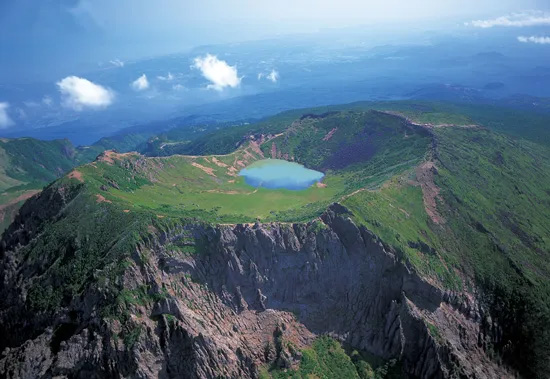
Rising 1,950 meters above sea level, Hallasan is South Korea’s highest mountain and the centerpiece of Hallasan National Park on Jeju Island. The mountain offers diverse ecosystems, volcanic landscapes, and seasonal beauty. Whether you’re looking for a short scenic walk or a challenging summit climb, Hallasan has a trail for every hiker.
The main routes vary in length, difficulty, and scenery — from forested paths to rocky ridges — making it possible to find the perfect fit for your time, stamina, and interests. From the long but gradual Seongpanak ascent to the steep and challenging Gwaneumsa, there is a route for every hiker.
The trail course is largely divided into two types: courses to the summit (Baengnokdam) (H1, H2) and courses to Witseoreum (H3, H4, H5).
To reach Baengnokdam, you need to have sufficient stamina and leave early in the morning, as it is about 18km away with an elevation gain of about 1,300m.
The journey to Witseoreum involves a 12km-17km distance with an elevation gain of 680m to 1,100m, depending on the course. The highlands surrounding Witseoreum are a unique and beautiful sight, unlike anywhere else in Korea.
- The rule is to complete the tour within a day. Access times are controlled by season to ensure descent before sunset. Access is also restricted when a weather warning is issued.
- You can find detailed information on each course as well as real-time trail control status on the Hallasan National Park websiteopen_in_new
- The course to Baengnokdam (summit) requires advance online reservations most of the year. The course to Witseoreum does not require advance reservations. Hallasan Visit Reservation Systemopen_in_new
- In Jeju City or Seogwipo City, you can call a taxi using an online app (Kakao Taxi) or take a bus to the entrance of the hiking trail.
- Taxi fares may vary depending on the area or traffic conditions, and some may charge a fixed rate depending on the destination.
- For detailed bus schedules and route information, we recommend using Naver Maps, Kakao Maps, or Google Maps. While the following site is available, it is not easy to use. Bus Informationopen_in_new
- Be sure to check your destination before boarding the bus. It may be in the opposite direction or on a different route.
- Unlike Jeju City or Seogwipo City, among the five entrances to Hallasan Mountain, Seongpanak has many buses and usually has many taxis waiting, but at all other entrances, it is difficult to catch a taxi using the Kakao Taxi app when descending, and waiting taxis are rare.
- If you plan to take a taxi after your descent, it's safest to call a taxi company in advance to reserve a time, pick-up location, and destination. Fares are more expensive than Kakao Taxi, so check in advance.
- To call a taxi in Jeju, call the number below. You should confirm language support directly when calling. If you don't speak Korean, you may experience difficulties using the service.
064-732-8282 (language support), 064-727-1111, 064-726-1000, 064-711-6666
Courses for Baengnokdam
| Course | Estimated Time (h) | Map Distance (km) | Elevation Gain|Loss (m) | Distance Ascent|Descent (km) | Gradient Ascent|Descent (%) | Difficulty |
|---|---|---|---|---|---|---|
Seongpanak - Baengnokdam | - | - | - - | - - | - - | star_borderstar_borderstar_borderstar_borderstar_border |
Gwaneumsa - Baengnokdam | - | - | - - | - - | - - | star_borderstar_borderstar_borderstar_borderstar_border |
To reach summit (Baengnokdam, P1), you must start from Seongpanak (H1) or Gwaneumsa (H2). The summit is not accessible from the other three starting points.
From summit you can either return to the starting point or descend to the opposite point of H1/H2.
As the elevation increases, the slope becomes increasingly steeper, and for most sections, the trail is covered in rough volcanic rock. (We strongly recommend wearing thick-soled, well-fitting hiking boots.)
As you get closer to the summit, the forest disappears and the view opens up, but in winter the wind blows very strongly.
Compared to the trail from Gwaneumsa, this one is longer, has a gentler slope, and involves less elevation gain. The path to the Jindallae Shelter is shaded by the forest, and the view near the summit is breathtaking.
The trail begins at approximately 780 meters above sea level, with a gentle slope at the bottom and a steeper incline from the midpoint, offering unique views of the ocean and Hallasan Mountain.
The path is covered in rough, uneven volcanic rock for nearly the entire route, making it quite tiring on the soles of your feet. In winter, the entire trail is covered in snow, making the ground condition less of a problem. However, in other seasons, thick-soled hiking boots are recommended.
Compared to the trail from Seongpanak, it's shorter, steeper, and climbs further. Most of the trail to Samgakbong Shelter (S3) is forested. You'll need to be strong enough to climb the steep climb.
It starts with a gentle slope at about 600m above sea level, and after about a third of the way up, the slope gets steeper. If you climb the steep slope a little past the Samgakbong Shelter, you can enjoy the beautiful scenery created by the volcanic eruption.
This section also has a lot of rough volcanic rock, and the overall slope is steeper and the elevation gain is greater (it is usually said to be a bit more difficult than starting from Seongpanak).
If you want to climb up to Baengnokdam (peak) more easily, the most common course is to start from Seongpanak (H1) and return to Seongpanak (H1).
If you're confident in your stamina and prefer a more varied view, we recommend the route starting at Gwaneumsa (H2) and descending to Seongpanak (H1).
In case from Gwaneumsa(H2) to Seongpanak(H1), After ascending the steep slope, the descent is gentler, less straining on the knees and offering panoramic views. Especially in winter, the rough volcanic rock path down through Seongpanak (H1) can be completely covered with snow, which can greatly reduce foot and knee fatigue.
If you plan to take a taxi or bus after descending, we recommend heading down to Seongpanak (H1). If you head down to Gwaneumsa (H2), buses run at long intervals (one hour), and catching a taxi can be difficult without prior reservation.
??Regardless of which course you choose, you must complete the hike on the same day. The long distance will make you increasingly fatigued and exhausted as you descend. Be sure to bring plenty of water and food.
??In winter, days are short and the summit is prone to strong winds and cold. Be prepared and set off as early in the morning as possible.
- Restroom: H1, H2, 4 Shelter(S1, S2, S3, S4)
- Store: There are no stores available along the entire route. (Prepare water and food in advance.)
- View in map: Naver Mapopen_in_newKakao Mapopen_in_newGoogle Mapopen_in_new
- Bus: At Jeju City Intercity Bus Terminal, take Bus 281 or Bus 181. Buses depart every 10 to 15 minutes, taking approximately 40 minutes.
Bus.281 scheduleopen_in_new, Bus.181 scheduleopen_in_new - Taxi: It takes about 30 minutes and costs approximately 15,000 to 20,000 won from Jeju Airport to Seongpanak.
- Parking: Due to the limited parking lot, it often fills up before the opening time during peak season. We recommend taking a taxi or bus if possible.
- View in map: Naver Mapopen_in_newKakao Mapopen_in_newGoogle Mapopen_in_new
- Bus: There is a bus number 475 that passes through Gwaneumsa, and it runs approximately every hour. You must take this bus into Jeju City and then transfer. Bus.475 scheduleopen_in_new
- Taxi: It costs approximately 20,000 won from Jeju Airport to Gwaneumsa and takes about 30 minutes. ??When using the bus, the interval between buses is long, so many people use taxis.
- Parking: There is a fairly large parking lot at the entrance, but it fills up early in the morning during peak season.
- The taxi fare between Gwaneumsa and Seongpanak is approximately 20,000 won, and the taxi fare from Jeju Airport to Jeju City Intercity Bus Terminal is around 10,000 won.
Courses for Witseoreum
| Course | Estimated Time (h) | Map Distance (km) | Elevation Gain|Loss (m) | Distance Ascent|Descent (km) | Gradient Ascent|Descent (%) | Difficulty |
|---|---|---|---|---|---|---|
Eorimok - Witseoreum | - | - | - - | - - | - - | star_borderstar_borderstar_borderstar_borderstar_border |
Yeongsil - Witseoreum Shelter | - | - | - - | - - | - - | star_borderstar_borderstar_borderstar_borderstar_border |
Donnaeko - Nambyeok | - | - | - - | - - | - - | star_borderstar_borderstar_borderstar_borderstar_border |
Nambyeok - Witseoreum Shelter | - | - | - - | - - | - - | star_borderstar_borderstar_borderstar_borderstar_border |
Near the summit of Hallasan's Yeongsil Trail, at elevations of 1,600-1,700 meters, are three consecutive peaks: Jogeun-oreum, Nuun-oreum, and Bulgeun-oreum. These three peaks are collectively known as Witseoreum. A shelter is located between the second and third peaks. The first, Jogeun-oreum, is accessible, and access to Witseoreum involves ascending from here.
The area surrounding Witseoreum is a highland grassland, one of Korea's most unique and charming. From April to June, the soft pinks of Korean azaleas and deep pinks of Korean rhododendrons blanket the area, creating a spectacular mountain flower garden. In winter, the area blends seamlessly with the snow-capped peak of Hallasan Mountain, creating a breathtaking landscape.
There are three interconnected starting points in this area: Eorimok (H3), Yeongsil (H4), and Donnaeko (H5). None of these points will lead to Baengnokdam (summit).
TThe course is a 4.4 km course, starting from the Eorimok Course entrance at approximately 990 m above sea level and ending at the Witseoreum Shelter (S5) Shelter at approximately 1,670 m. Including the 2 km round trip from the shelter to Witseoreum (Jogeun-oreum), the total distance is approximately 6.4 km. The slope is steep until about halfway through the course, then gradually flattens out.
When returning from Shelter (S5) to Eorimok (H3), you usually go back and forth (about 2km) to Jogeun-oreum (P2) and then go down.
If you don't need to return to your starting point, you can descend further (6.7km) to Yeongsil (H4). If you want to take a longer route, you can either do a round trip to Nambyeok (P3) (4.6km) and then descend to Yeongsil (H4) (6.7km). Alternatively, you can pass through Nambyeok (P3) and descend to Donnaeko (H5) (2.3km + 7.8km). Public transportation from Donnaeko (H5) is somewhat inconvenient.
The course starts from Yeongsil Information Center (H4) at approximately 1,030m above sea level and ends at Witseoreum shelter at approximately 1,670m above sea level.
There is a Rest Area and Parking Lot (S6) 2.5km above the Yeongsil Information Center (H4) (1,250m above sea level). Vehicles can drive up to this point. However, buses do not run there, and during peak season, you must arrive early to access the area.
From the rest area, after about 1km of forest trail and a steep 1.5km climb up the stairs, the arduous part of the trail is over. From here, unless you climb a hill, the trail is mostly flat. After enjoying the view, continue a short distance along the deck path, and you'll reach the alpine meadows where Witseoreum is located. Continue along the beautiful flat deck path until you reach the Witseoreum Shelter.
If you have the energy, you can hike from here to Nambyeok (P3) and back (6.6km round trip), taking in the beautiful alpine meadows from Hallasan's east face to its south face. This section is mostly flat.
If you don't need to return to the starting point, you will have to go to Eorimok (H3) a lot, and if you go down to Donnaeko (H5), you will have to go a relatively long and boring distance.
Starting at Donnaeko (H5), at an elevation of 500m, this 7.8km course reaches Nambyeok (P3), at an elevation of 1,600m. With an elevation gain of approximately 1,100m, it's a somewhat challenging course.
A gentle climb continues until the 1,450m Pyeonggwae Shelter (S7), approximately 6km from the start. From here, the trail continues to Nambyeok (P3), where the terrain is mostly flat and features extensive basalt deposits of Hallasan's Baengnokdam crater, offering breathtaking views of the south wall.
You can pass Witseoreum Shelter (S5) and go down to Eorimok (H3) or Yeongsil (H4).
A 2.3km connecting section of the highland area from Nambyeok (P3) to Witseoreum Shelter (S5), connecting Donnaeko (H5) and Eorimok (H3)/Yeongsil (H4).
This section features gently sloping terrain, offering breathtaking views of the southern crater wall of Baengnokdam and the beautiful scenery of Hallasan Mountain. In winter, visitors can enjoy the expansive snowfields of the highland plains.
If you start from Eorimok (H3) or Yeongsil (H4), you can enjoy the unique charm of Hallasan Mountain by making a round trip through this section.
Focusing on Jogeun-oreum (P2), the accessible climb, the two courses, Eorimok (H3) and Yeongsil (H4), have nearly identical distances (5.5 km) and elevation gains. However, Yeongsil (H4) is a 2.5 km section of road from the entrance to the rest area. Since the rest area can be reached by taxi or car, excluding this, Yeongsil (H4) is the shortest course (3 km).
The Eorimok (H3) arrow_back-right Witseoreum Shelter (S5) course is the most popular due to its short distance, excellent views centered around Witseoreum, and well-maintained hiking trail.
If you are confident in your stamina and can leave early in the morning, we recommend the 15.6 km course below or the reverse course. If you need to return to the starting point, you can take a taxi.
Eorimok (H3) arrow_forward Witseoreum Shelter (S5) arrow_forward Nambyeok (P3) arrow_forward Witseoreum Shelter (S5) arrow_forward Yeongsil (H4)
- Restroom: H3, H4, rest area (S6), 2 shelters
- Store: There are no stores along the entire route except for one Rest Area (S6). (Prepare water and food in advance.)
- View in map: Naver Mapopen_in_newKakao Mapopen_in_newGoogle Mapopen_in_new
- Bus: From Jeju City Intercity Bus Terminal, take Bus No. 240 (Bus.240 schedule). (Bus.240 scheduleopen_in_new)
Buses depart every 50-60 minutes, and the journey takes approximately 40 minutes. After getting off, walk 15 minutes to the entrance. - Taxi: From Jeju Airport, it costs 20,000 to 25,000 won and takes about 40 minutes to 1 hour..
- Parking: There's a paid parking lot near the trail entrance. It offers more parking than Yeongsil.
- View in map: Naver Mapopen_in_newKakao Mapopen_in_newGoogle Mapopen_in_new
- Bus: From Jeju City Intercity Bus Terminal, take bus number 240 (Bus.240 scheduleopen_in_new).
Buses depart every 50-60 minutes, and the journey takes about 60 minutes. After getting off, walk 2.5 km to the rest area or take a taxi. - Taxi: It costs about 30,000 won and takes about 40 to 50 minutes from Jeju Airport to Yeongsil Ticket Office.
- Parking: Due to the limited parking lot, it often fills up before the opening time during peak season. We recommend taking a taxi or bus if possible.
- View in map: Naver Mapopen_in_newKakao Mapopen_in_newGoogle Mapopen_in_new
- Bus: From Seogwipo City, take buses 611 and 612. (Bus.611 scheduleopen_in_new)
It's a 20-minute walk from the Chunghon Cemetery Plaza stop. Buses depart every 30 to 40 minutes. - Taxi: Donnaeko is close to Seogwipo City, opposite Jeju Airport, and is centered around Hallasan Mountain. It costs about 50,000 won based on Jeju Airport.
- Parking: There is a parking lot at the entrance to Donneko Amusement Park.
- If you plan to take the bus, you should check in advance as the interval between buses is long and the schedule may change.
- During the winter season, buses passing through Eorimok/Yeongsil may experience changes, such as increased service intervals on existing routes, the creation of new temporary routes, and shorter service intervals on weekends and holidays. Bus service intervals may be significantly reduced.
It's more convenient to use a map app like Naver Maps, Kakao Maps, or Google Maps than to manually search for updated operating hours or temporary route information.