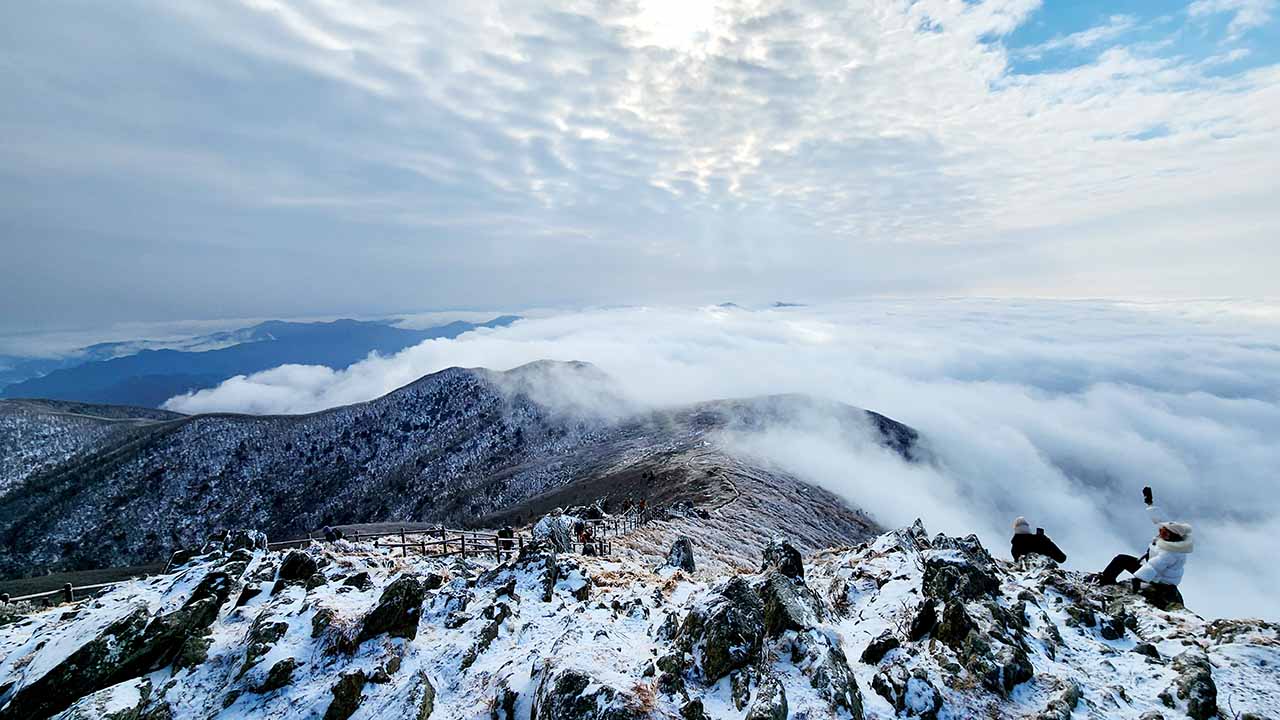
Deogyusan National Park spans parts of North Jeolla Province and South Gyeongsang Province. Its highest peak, Hyangjeokbong Peak (1,614m), is the fourth highest peak in South Korea and is particularly renowned for its beautiful winter scenery and snowy peaks. It offers a variety of hiking trails for both beginners and experienced hikers.
For Korean hiking enthusiasts, it's a must-visit during the winter season.
Trail Overview
Deogyusan Mountain boasts family-friendly trails along forest paths and gently sloping ridges offering panoramic views. While winter brings a dramatic change to the landscape with frozen ice and snow, spring and fall offer more tranquil weather and expansive views.
While the Hyangjeokbong and Namdeogyusan areas are part of the same national park, stretching along a long ridge, most hikers find it challenging to reach both areas in a single day. Many hikers choose to hike separately or as part of a day hike (traveling to the starting point at night and starting the hike at dawn).
Centered around Hyangjeokbong Peak (P2), the highest peak of Deogyusan Mountain, the ridge connects Seolcheonbong Peak (P1) and Jungbong Peak (P3), extending to Namdeogyusan Peak (P4). The area around Hyangjeokbong Peak (P2) is characterized by its gentle slopes and frequent winds. On clear days, it offers panoramic views of Muju and the surrounding mountain ranges.
Access is available from Muju Resort/Seolcheon Base (H7), Gucheon-dong Visitor Center (H1), and Anseong Visitor Center (H6). The ridge is also accessible from Namdeogyusan.
From Muju Resort/Seolcheon Base (H7), you can take a gondola up to Seolcheonbong Peak, offering a chance to enjoy the beautiful winter scenery of Hyangjeokbong Peak with your family.
Deogyusan Hyangjeokbong Peak is the only peak among Korea's famous mountains easily accessible by gondola or cable car.
Namdeokyusan (P4) is one of Deogyusan's main peaks, particularly famous for its beautiful snow flowers and frost-covered trees in winter. A gentle, long ridge leads from Namdeokyusan to Hyangjeokbong Peak.
Many hikes begin at Yeonggaksa Temple (H4), and you can either return or descend via Hwangjeom Village (H3) or Yuksipryeong Pass (H5). The reverse route is also possible.
Namdeokyusan, along with Hyangjeokbong, is one of the mountains you must visit in winter.
Deogyusan Region Courses
The courses introduced here are representative courses that climb peaks such as Hyangjeokbong (P2), the highest peak of Deogyusan, Seolcheonbong (P1), and Jungbong (P3).
| Course | Estimated Time (h) | Map Distance (km) | Elevation Gain|Loss (m) | Distance Ascent|Descent (km) | Gradient Ascent|Descent (%) | Difficulty |
|---|---|---|---|---|---|---|
Anseong - Muju Resort | - | - | - - | - - | - - | star_borderstar_borderstar_borderstar_borderstar_border |
Anseong - Gucheondong | - | - | - - | - - | - - | star_borderstar_borderstar_borderstar_borderstar_border |
Gucheondong - Hyangjeokbong (round trip) | - | - | - - | - - | - - | star_borderstar_borderstar_borderstar_borderstar_border |
This beautiful course begins at the Anseong Visitor Center (H6) and continues along the main ridge of Deogyusan Mountain, from Dongyeopryeong (K3) to Jungbong (P3), Hyangjeokbong (P2), and Seolcheonbong (P1), connecting to Muju Resort (H7). As you pass through the ridges and major peaks, you'll enjoy sweeping views.
This course offers the advantage of experiencing the main ridge of Deogyusan Mountain and the ease of descending from Seolcheonbong (P1) via the gondola. However, the gondola may be out of service due to strong winds or maintenance, in which case you'll need to descend to Gucheondong (H1).
This is the most attractive course, offering the opportunity to enjoy both the highest peak and the ridge while minimizing physical strain.
- Restroom: H6, S1, H7
- Restorent: H6, H7
- Parking: H6, H7
This cross-country course begins at Anseong (H6) and follows the main ridge, extending from Dongyeopryeong (K3) to Jungbong (P2) and Hyangjeokbong (P1), before descending (7.4km) to Gucheondong (H1).
The ridge path features repeated ups and downs, with some sections staying above the tree line for extended periods. The descent to Gucheondong Valley begins with a steep descent to Baekryeonsa Temple, followed by a somewhat tedious, gentle descent over a long distance.
This is the most common route used by hiking clubs to reach the highest peak of Deogyusan Mountain.
- Restroom: H6, S1, H1
- Restorent: H6, H1
- Parking: H6, H1
This is a classic round-trip trail from Gucheondong (H1) to Hyangjeokbong (P2), the highest peak of Deogyusan.
The long lower valley trail follows the stream, with a deck and forest path, while the upper part is a series of rock slabs and long stone steps, becoming increasingly exposed and windy as you near the summit.
Compared to the cross-country trail starting from Anseong (H1), the lower valley trail continues for a longer time, making the total distance slightly longer. However, this trail is a good option if you have limited access to trailheads.
- Restroom: H1, S1
- Restorent: H1
- Parking: H1
Namdeogyusan Region Courses
The courses introduced here are courses to climb Namdeogyusan (P4).
| Course | Estimated Time (h) | Map Distance (km) | Elevation Gain|Loss (m) | Distance Ascent|Descent (km) | Gradient Ascent|Descent (%) | Difficulty |
|---|---|---|---|---|---|---|
Yeonggak - Wolsongjae - Hwangjeom | - | - | - - | - - | - - | star_borderstar_borderstar_borderstar_borderstar_border |
Yeonggak - Satgatjae - Hwangjeom | - | - | - - | - - | - - | star_borderstar_borderstar_borderstar_borderstar_border |
Yuksipnyeong - Hwangjeom | - | - | - - | - - | - - | star_borderstar_borderstar_borderstar_borderstar_border |
This course begins at Yeonggak Visitor Center (H4), ascends Namdeokyusan (P4), reaches Wolseongjae (K4), and descends to Hwangjeom Village (H3).
The first ascent of Namdeokyusan is a gentle, easy walk along the valley, with a cool breeze. About 1km before reaching the summit, a steep climb and a long iron staircase begin. Once there, a beautiful landscape of bizarre rock formations and unusual rock formations unfolds before you.
While it's possible to return to Yeonggaksa Temple from the summit, this course instead enters the main ridge, passes Wolsongjae (K4), and descends to Hwangjeom Village (H3).
The iron staircase, which begins about 1km before the summit from Yeonggaksa Temple, creates a truly iconic scene, especially in winter when covered in snow.
- Restroom: H4, H3
- Restorent: H4, H3
- Parking: H4, H3
This course begins at Yeonggak Visitor Center (H4), ascends Namdeogyusan (P4), and follows the main ridge from the summit, traveling 3.8km to Satgatjae Shelter (S2). From there, descend to Hwangjeom Village (H3).
If you want to experience the main ridge of Deogyusan along with the summit of Namdeogyusan, this course is a great choice.
- Restroom: H4, S2, H3
- Restorent: H4, H3
- Parking: H4, H3
This course begins at Yuksipryeong Pass (H5), ascends Namdeokyusan (P4), passes Wolsongjae (K4), and descends to Hwangjeom Village (H3).
The 7.9km route to the summit is a mix of steep and gentle slopes, and old forest paths, and the trails also feature ups and downs, making it more physically demanding than the climb from Yeonggaksa Temple (H4).
- Restroom: H5, H3
- Restorent: H3
- Parking: H5, H3
Long distance ridge courses
The courses featured here are long-distance treks, including Korean three major treks. They are recommended only for those who have experience with courses of similar difficulty and are confident in their physical fitness. They are also ideal with a leisurely one- or two-night stay.
| Course | Estimated Time (h) | Map Distance (km) | Elevation Gain|Loss (m) | Distance Ascent|Descent (km) | Gradient Ascent|Descent (%) | Difficulty |
|---|---|---|---|---|---|---|
Yeonggak - Anseong | - | - | - - | - - | - - | star_borderstar_borderstar_borderstar_borderstar_border |
Yeonggak - Gucheondong | - | - | - - | - - | - - | star_borderstar_borderstar_borderstar_borderstar_border |
Yuksipnyeong - Gucheondong | - | - | - - | - - | - - | star_borderstar_borderstar_borderstar_borderstar_border |
Starting from Yeonggaksa Temple (H4), climb Namdeogyusan (P4), follow the long ridge trail to Dongyeopryeong (K3), and then descend to Anseong Visitor Center (H6).
Compared to descending to Gucheondong (H1), this route offers the advantage of experiencing the main ridge of Deogyusan while being about 8km shorter.
Compared to descending to Seolcheonbong (P1) via a gondola, this route is about the same distance, but without the ascent or descent to Seolcheonbong, it consumes less energy. If you have the stamina to spare from Dongyeopryeong (K3), I recommend taking the gondola from Seolcheonbong (P1) to descend.
- Restroom: H4, H6
- Restorent: H4, S2, H6
- Parking: H4, H6
This course climbs Namdeokyusan (P4) from Yeonggaksa Temple (H4), follows the main ridge to Hyangjeokbong Peak (P2), and descends to Gucheondong Valley (H1).
Compared to starting from Yuksipryeong (H5), this route is approximately 3.6km shorter and gains approximately 2.3km less elevation, allowing you to enjoy the essence of Deogyusan while reducing your physical exertion.
- Restroom: H5, S2, S1, H1
- Restorent: H1
- Parking: H5, H1
This course is the longest ridge in Deogyusan Mountain. It follows the ridge from Yuksipnyeong (H5) toward the central highlands, following a wide undulation before descending to the Gucheondong Valley (H1).
This course allows you to experience the essence of Deogyusan Mountain, allowing you to enjoy a journey from point to point. It's also one of Korean three major ridge courses.
- Restroom: H5, S2, S1, H1
- Restorent: H1
- Parking: H5, H1