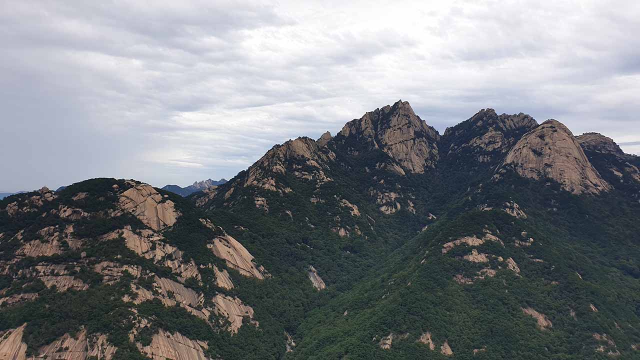
Bukhansan National Park, spanning Seoul and Gyeonggi Province, is a vast granite mountain with a variety of peaks, ridges, and valleys.
Its highest peak, Baegundae (836m), and the majestic Insubong and Manggyueondae, have earned it the nickname "Samgaksan" (Three-peak Mountain). The numerous rock walls and peaks offer breathtaking scenery and a variety of climbing options, from expert to beginner.
Easy access by public transportation, breathtaking views, and historical sites, including Bukhansan Fortress, make it one of the best hiking trails in the Seoul metropolitan area.
Bukhansan isn't as large as Jirisan or Seoraksan. However, its entirety appears to be a single, massive granite boulder, giving it a majestic, unique beauty and feel. It's one of the most sought-after mountains in Korea, rivaling any other.
Trail Overview
Here are the key sections of Bukhansan's major trails. Major trails pass through one or more of the sections listed here.
Major areas: Baegundae Peak (P1), Sumunbyeok Ridge (H2-K7), Manggyueondae Ridge (K6-K7), Bukhansanseong Ridge (K3-K6), Uisang Ridge (H1-K3), Bibong Ridge (H10-P4)
Baegundae Peak of Bukhansan, at 836 meters above sea level, is the highest peak in Seoul and the iconic symbol of Bukhansan National Park.
It's composed of granite, and the summit area features steep stone steps and iron railings, making it a challenging climb.
The summit offers breathtaking views of majestic rock peaks and sheer cliffs. If you're confident in your fitness and only visit Bukhansan once, this is the place to start.
This approximately 3km trail connects Bamgol Entrance, via Sumunbyeok, with Baegundae. The name Sumunbyeok (Hidden Wall) comes from the fact that its existence is not easily visible, hidden by the surrounding peaks.
After passing through the forest path that continues for about 2km, you will arrive at Sumunbyeok, a steep rocky terrain. After that, you will descend a little into the valley and climb steep stone steps until you reach the ridge, making it a dynamic course.
This trail, located on a rocky ridge between Baegundae and Insubong, alternates between forest paths and rocky ridges, offering a fun hike and breathtaking views. Along with Uisang Ridge, it's one of the most beloved ridges. The autumn foliage is particularly beautiful.
Manggyeondae, along with Baegundae and Insubong, is one of the highest peaks of Bukhansan Mountain. This approximately 1km section passes through the upper waist of Manggyeondae.
This route is a thrilling climb that traverses unique rocky terrain. While relatively challenging, it offers panoramic views.
If you pass through Baegundae, we recommend including this section if possible.
This 3.5km course follows the fortress wall from Daenammun Gate in Bukhansanseong, past Daedongmun Gate, to Yongammun Gate, offering a chance to enjoy both scenery and history.
Because it follows the walls of Bukhansanseong Fortress, the rock climbing difficulty is low and the trail is well-maintained. However, compared to other hiking trails, it can be somewhat tedious, and with many small ascents and descents, it can be more challenging than expected.
This 4km ridge trail connects the Bukhansanseong Visitor Center (H1) to Uisangbong (P3) and then to Daenammun (K3). It boasts the most dynamic and spectacular rock beauty in Bukhansan.
Starting from the Bukhansanseong Visitor Center (H1), follow the paved road for approximately 350m. After taking the right fork, the trail ascends gently for 1.4km. From here, the trail ascends steeply to Uisangbong Peak, a massive rock ridge that can be quite challenging for beginners. From Uisangbong Peak, the trail ascends and descends through six peaks before reaching Daenammun.
This trail offers the thrill of ascending and descending the sharp peaks, and upon reaching the ridge, a panoramic view of Baegundae, Manggyeondae, Insubong, and other peaks unfolds before your eyes. This section is recommended as a priority for those confident in their hiking skills. It requires significant physical effort and features steep, rocky slopes that can be dangerous in rain or snow. Beginners are advised to choose other routes if possible.
This ridge trail begins near Bulgwang entrence(H10) and extends approximately 5km to Munsubong(P5). The course offers numerous photo opportunities, including numerous peaks and unique rock formations, and some sections feature challenging rocky ridges.
Following the ridge, you can enjoy panoramic views of Seoul and a variety of unique rock formations. The trail from the ridge below Munsubong(P5) to Hyangnobong(P6) Peak is approximately 2km, mostly flat with slight ups and downs, making it a relatively easy hike.
Uisang Ridge, Sumunbyeok Ridge: The most dynamic and scenic. If you can't visit all the other areas, including one of these two sections will allow you to experience the most distinctive features of Bukhansan.
Bukhansan has many steep, rugged rocky trails. We recommend properly fitting hiking boots and gloves. Avoid trails like Sumunbyeok Ridge and Uisang Ridge after heavy rain or in winter, as they can be dangerous.
Courses for Baegundae peak
Below, we compare and explain some of the most popular courses among the many routes to climb Baegundae (P1), the highest peak of Bukhansan.
| Course | Estimated Time (h) | Map Distance (km) | Elevation Gain|Loss (m) | Distance Ascent|Descent (km) | Gradient Ascent|Descent (%) | Difficulty |
|---|---|---|---|---|---|---|
Bukhansanseong Visitor Center - Baegundae | - | - | - - | - - | - - | star_borderstar_borderstar_borderstar_borderstar_border |
Sumunbyeok - Bukhansanseong Visitor Center | - | - | - - | - - | - - | star_borderstar_borderstar_borderstar_borderstar_border |
Ui-dong - Baegundae | - | - | - - | - - | - - | star_borderstar_borderstar_borderstar_borderstar_border |
Bukhansanseong Visitor Center - Ui-dong | - | - | - - | - - | - - | star_borderstar_borderstar_borderstar_borderstar_border |
This course begins at the Bukhansanseong Visitor Center (H1) and follows the Sangunsa Valley to Baegundae (P1), and then returns to the starting point via Manggyeondae Ridge and Bukhansan valley .
The first half of the ascent is a gentle climb, with the sound of water. The second half tests your stamina as you ascend steep stone steps. On the descent, you'll pass through Manggyeondae ridge, taking in the beauty of the Mangyeongdae rock ridge trail and its stunning scenery. Afterwards, you'll take a detour and descend gently, reducing the impact on your knees.
This is the most popular route from the Bukhansanseong Visitor Center (H1) to Baegundae.
- Restroom: H1, S1, K1
- Restaurant: H1
- Parking: H1
This course starts from Bukhansan Bamgol Entrance (H2) and goes up to Sumunbyeok, then passes through the road between Insubong and Baegundae and goes up to Baegundae (P1). This course then passes Manggyeondae Ridge, descends through Bukhansan Shelter (S1) into Bukhansan Valley, and returns to the Bukhansanseong Visitor Center (H1).
While initially a gentle trail, the trail gradually encounters diverse and dynamic terrain, including rock faces, cliffs, and steep stone steps. The numerous rugged ridges and cliff sections offer thrilling views and stunning views, making it one of the most popular trails.
Along the way, you'll encounter unique rock formations like Madangbawi Rock, Skeleton Rock, and Seal Rock. Climbing Sumunbyeok reveals a magnificent view of Bukhansan, unique to this area. The autumn foliage is particularly beautiful.
Due to the numerous rocky sections, it's best to choose a different route or exercise extreme caution during winter or after rain. Parking is limited at Bamgol Entrance, so take public transportation or park at the Bukhansanseong Visitor Center and take a bus to Bamgol Entrance.
- Restroom: H2, H1, S1, K1
- Restaurant: H1
- Parking: H1
Starting from Ui-dong (H4), the trail passes through Harujae (K8) and Yeingbong (P5), then ascends to Baegundae Shelter (S2) and Baegundae (P1). The descent takes you through Manggyeondae Ridge, Yongammun (K6), and back to Ui-dong (H4), returning to the starting point.
The initial portion of the trail is relatively gentle, but after passing Harujae, the slope begins to steepen, and the slope becomes steeper as you head toward the Baegundae summit. Baegundae Shelter (S2), just past Harujae, is a great place to rest.
Departing from Ui-dong offers better public transportation access compared to departing from Bukhansanseong Visitor Center (H1), but the elevation gain is about 100m higher.
If you take a taxi from Ui Station to Baegundae Visitor Center (H5) when starting your hike, you'll save about 1.8km compared to H4, making this the shortest route to Baegundae. Moreover, if you make a round trip from this point to Baegundae, it is less than 4km, making it a more direct route to and from Baegundae.
- Restroom: H4, H5, S2
- Restaurant: H3, H4
- Parking: H4, H5
Departing from the Bukhansanseong Visitor Center (H1), hikers ascend to Baegundae (P1) via the shortest valley path. The descent begins at Baegundae Shelter (S2), then passes through Harujae (K8) to Yeingbong (P5), then via Soguicheon Park (K6) and descends to Ui-dong (H4).
This course is a combination of half of the Bukhansanseong Visitor Center origin return course and half of the Ui-dong (H4) origin return course, allowing you to see both the north and south of Baegundae. Before descending to Ui-dong (H4), you can take a taxi from the Baegundae Visitor Center (H5) to Ui-dong Station. This shortens the distance to Ui-dong (H4) by approximately 2.4km and the distance to H4 by approximately 1.8km.
If you arrive early, parking is available at the Baegundae Visitor Center. There is a shuttle bus to Ui Station used by the followers of Doseonsa Temple, but if there are empty seats, the general public can also use it for 1,000 won.
- Restroom: H1, K1, S2, H4, H5
- Restaurant: H1, H3, H4
- Parking: H1, H4, H5
Courses for Short distance
Here are some shorter courses to climb other peaks besides Baegundae on Bukhansan.
| Course | Estimated Time (h) | Map Distance (km) | Elevation Gain|Loss (m) | Distance Ascent|Descent (km) | Gradient Ascent|Descent (%) | Difficulty |
|---|---|---|---|---|---|---|
Bukhansanseong Visitor Center - Weonhyobong | - | - | - - | - - | - - | star_borderstar_borderstar_borderstar_borderstar_border |
Bukhansanseong Visitor Center - Uisang Ridge | - | - | - - | - - | - - | star_borderstar_borderstar_borderstar_borderstar_border |
This course begins at the Bukhansanseong Visitor Center (H1), passes Wonhyoam Temple, ascends Weonhyobong (P2), and then descends toward the Bukhansan Valley before returning to the starting point.
It's the shortest of the recommended courses and, compared to other trails like Baegundae, is easier. The summit offers breathtaking views of Seoul, Uisangbong, Insubong, and other peaks of Bukhansan.
If you are looking for the easiest course to climb a peak among the Bukhansan hiking courses, I recommend this course.
- Restroom: H1, K1
- Restaurant: H1
- Parking: H1
This course starts from Bukhansanseong Visitor Center (H1), passes Uisangbong (P3), Yongchulbong, Yonghyeolbong, and Jeungchwibong. After Jeungchwibong, there is a three-way intersection (before going to Bugwangdong-Ammun (K2)). Take the left and go down Bukhansan Valley and return to the starting point.
From the starting point, follow the paved road to the right for approximately 350 meters and take the right fork. Following this, the trail continues through a forest for approximately 1.5 kilometers, ascending a steep, rugged rocky ridge to Uisangbong Peak. After this, there are several ups and downs to Jeungchwibong.
As you ascend and descend various peaks, you'll experience Bukhansan's uniquely rugged granite ridges and some of its most spectacular scenery. During the fall foliage season, you can enjoy stunning autumn foliage along the forest trail from Jeungchwibong Junction on the way down to Bukhansan Valley. This is one of the most popular sections among Bukhansan enthusiasts.
While short, this trail features challenging climbs and descents of several sharp peaks. The early section, which climbs Uisangbong Peak, is particularly steep and rocky. Gloves and well-fitting hiking boots are highly recommended. Avoid this trail after rain or in winter, or exercise extreme caution.
- Restroom: H1, K1
- Restaurant: H1
- Parking: H1
Courses for Long distance
If you're confident in your stamina, try the course that connects Bukhansan's most attractive ridges. You can enjoy each attraction simultaneously. However, because the trail features steep ups and downs and many rugged rocky paths, you should consider the physical exertion far greater than expected given the distance. We recommend doing thorough research before embarking on your hike.
| Course | Estimated Time (h) | Map Distance (km) | Elevation Gain|Loss (m) | Distance Ascent|Descent (km) | Gradient Ascent|Descent (%) | Difficulty |
|---|---|---|---|---|---|---|
Uisang Ridge - Bibong Ridge | - | - | - - | - - | - - | star_borderstar_borderstar_borderstar_borderstar_border |
Sumunbyeok - Uisang Ridge | - | - | - - | - - | - - | star_borderstar_borderstar_borderstar_borderstar_border |
Bukhansan Main Ridge Trail | - | - | - - | - - | - - | star_borderstar_borderstar_borderstar_borderstar_border |
This course connects the Uisang Ridge, Bukhansan's most dynamic and steeply sloping ridge, with the relatively flat Bibong Ridge, which offers numerous photo opportunities.
Since Uisang Ridge requires considerable stamina, we recommend resting at Munsubong (P4), where it meets Bibong Ridge, and taking in the stunning views before continuing. Be careful of the short, but steep, cliff face at the connection to Bibong Ridge. Entering Bibong Ridge, the trail continues with gentle ups and downs to Hyangnobong (P7), offering breathtaking views. After Hyangnobong Peak, the actual descent begins.
This trail begins at the Bukhansanseong Visitor Center (H1) and, after entering Uisang Ridge, has no restrooms, including at the destination, Bulgwang Entrance (H10). To use the restrooms, you must travel 1.2km to Bulgwang Station.
If you park at the Bukhansanseong Visitor Center (H1), you can easily reach your departure point by taking a taxi from your destination (H10). To use a taxi, walk a short distance to the road and then use a taxi app.
- Restroom: H2, H1, S1, K1
- Restaurant: H1
- Parking: H1
This course connects Sumunbyeok Ridge, Manggyeondae Ridge, Bukhansanseong Ridge, and Uisang Ridge, circling the main ridge of Bukhansan in a U-shape. It offers the dynamic and captivating experience of Sumunbyeok Ridge, Uisang Ridge, and the historic Bukhansanseong Ridge, making it a recommended course for only experienced hikers.
You can start from either Sumunbyeok Ridge (H2) or Uisang Ridge (H1), but the Sumunbyeok side is more common. The ascent of Sumunbyeok Ridge offers better views. If you're feeling exhausted, there are several paths from Uisang Ridge before reaching Uisangbong Peak.
If you start from Sumunbyeok, Daedongmun (K5) is the last restroom. Restrooms are only available at Bukhansanseong Visitor Center(H1).
- Restroom: H2, H1, S1, K5
- Restaurant: H1
- Parking: H1
This trail, which begins at Bulgwang-dong Entrance (H10) at the western end of Bukhansan, traverses the main ridges of Bukhansan, passing through Bibong Ridge, Bukhansanseong Ridge, Baegundae (P1), Yeingbong (P5), and Ui Ridge, ending at Ui Station (H3) at the eastern end. It is the longest trail.
The distance is long and the trail features numerous ups and downs, making it highly tiring and likely to take longer than expected. We recommend starting early in the morning on a spring or fall day with good weather. As with other Bukhansan trails, water and food cannot be refilled along the way, so be sure to prepare in advance. Past Yeongbong Peak, the Ui Ridge offers many beautiful rock formations perfect for resting.
- Restroom: K5, S1, S2, S3, H3
- Restaurant: H3
- Parking: H3